Iowa Crop Progress and Condition Report
April 19 - 25, 2021
DES MOINES, Iowa (April 26, 2021) — Iowa Secretary of Agriculture Mike Naig today commented on the Iowa Crop Progress and Conditions report released by the USDA National Agricultural Statistics Service. The report is released weekly from April through November.
“We’ve seen improvement in drought conditions across western Iowa,” said Secretary Naig. “Colder temperatures and some late-season snow slowed farmers down last week. However, recent weather patterns have allowed more farmers to get into the fields and a warm and windy forecast should ramp up field activities in the coming days.”
The weekly report is also available on the USDA’s website at nass.usda.gov.
Crop Report
Below normal temperatures during the week ending April 25, 2021 delayed planting for some farmers but as the weekend neared, planting accelerated according to the USDA, National Agricultural Statistics Service. Statewide there were 5.6 days suitable for fieldwork during the week. Field activities for the week included applying anhydrous and dry fertilizer, tilling fields and planting.
Topsoil moisture levels rated 6% very short, 28% short, 64% adequate and 2% surplus. Subsoil moisture levels rated 10% very short, 35% short, 54% adequate and 1% surplus.
Despite hesitancy due to cold soil temps, 20% of Iowa’s corn crop has been planted, one day behind the 5- year average. Some farmers chose to plant soybeans with 6% of the crop planted, 3 days ahead of normal. Eighty-three percent of Iowa’s expected oat crop has been planted, 3 days ahead of last year and 6 days ahead of the 5-year average. Statewide 29% of the oat crop has emerged, 3 days ahead of average.
Pasture condition rated 45% good to excellent. Calving is reportedly going well. Despite pasture and hay being slow to grow, cattle are on pastures.
Weather Summary
Provided by Justin Glisan, Ph.D., State Climatologist, Iowa Department of Agriculture and Land Stewardship
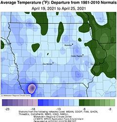
Although not unusual for this time of April, late-season measurable snow fell on multiple days during the reporting period. Even with measurable precipitation at a majority of the state’s reporting stations, unseasonable dryness was observed statewide. Colder than average conditions persisted through Iowa with temperatures up to 12 degrees below normal; the statewide average temperature was 41.7 degrees, 11.1 degrees below normal.
Partly cloudy skies remained during Sunday (18th) afternoon with a steady wind out of the west. Afternoon temperatures were generally in the low to mid 60s with a statewide average high of 62 degrees, climatologically normal for the date. A cold front swept through the state overnight into Monday (19th) bringing much cooler temperatures. Behind the front, rain switched over to snow during the morning hours with a rain and snow mix persisting over much of Iowa’s western half and along the Iowa-Missouri border. Light rain and some snow remained across southeastern Iowa on Tuesday (20th) morning with a majority of Iowa’s stations reporting a temperature below 32 degrees. Event snow totals reported at 7:00 am were generally under a half of an inch, though 10 stations reported an inch or more; Little Sioux (Harrison County) measured 2.7 inches while Sibley (Osceola County) reported 4.0 inches. Daytime temperatures rebounded into the mid to upper 40s with the statewide average high of 45 degrees, 18 degrees below normal. Iowa experienced another frosty morning on Wednesday (21st) with a vast majority of thermometers falling below 28 degrees, leading to a late-season freeze. With the sun shining and a southerly wind, warmer afternoon temperatures were observed, from the upper 50s to low 60s across the state.
High pressure built into the region Thursday (22nd) as southerly flow pushed daytime highs into the upper 50s and low 60s under sunny skies. Overcast conditions developed overnight into Friday (23rd) holding temperatures in the mind to upper 40s with some spotty light rain showers in western Iowa. Southerly winds increased over the late morning hours as a weak low pressure system sluggishly moved across northern Iowa, shifting winds to a northerly direction from west to east through the early morning hours on Saturday (24th). Starry skies were reported in the southern quarter of the state, while clouds remained over the rest of Iowa as the low’s attendant cold front propagated southeast. Lows reported at 7:00 am ranged from the upper 30s to low 40s with very light rain totals across southeastern Iowa. Clouds cleared in the west through the morning hours and sunny conditions advanced east through the evening. Daytime highs reached the low 50s north to low 60s south, still four to ten degrees below average. Clouds redeveloped in western Iowa ahead of disturbance into Sunday (25th) morning with reports of light rain and some snowflakes in the northwest corner; Orange City (Sioux County) observed 0.08 inch at 7:00 am.
Weekly precipitation totals ranged from no accumulation at many stations in west-central and eastern Iowa to 0.37 inch in Sibley (Osceola County). The statewide weekly average precipitation was 0.05 inch while the normal is 0.80 inch. Sioux City Airport (Woodbury County) and Davenport Municipal Airport (Scott County) reported the week’s high temperature of 67 degrees on the 23rd and 24th, respectively; this reading is on average one degree above normal. Sibley and Stanley (Buchanan County) reported the week’s low temperature of 16 degrees on the 21st, on average 20 degrees below normal. Four-inch soil temperatures were in the low 40s northeast to mid 50s southwest as of Sunday.

