Iowa Crop Progress and Condition Report
Nov. 22 – 28, 2021
DES MOINES, Iowa (Nov. 29, 2021) — Iowa Secretary of Agriculture Mike Naig commented today on the Iowa Crop Progress and Condition report released by the USDA National Agricultural Statistics Service. The report is released weekly from April through November.
“This week marks the end of the 2021 weekly crop progress and condition report from USDA NASS,” said Secretary Naig. “Over the last year, we’ve seen how resilient Iowa agriculture is in the face of weather challenges and persistent dryness. Drought conditions are still lingering in some parts of the state but given the wet weather pattern over the last several weeks and much needed soil moisture recharge, I’m optimistic for the 2022 growing season conditions.”
The weekly report is also available on the USDA’s website at nass.usda.gov.
Crop Report
Continued dry conditions allowed Iowa’s farmers 6.5 days suitable for fieldwork during the week ending November 28, 2021, according to the USDA, National Agricultural Statistics Service. Field activities included harvesting corn for grain, baling corn stalks, applying fertilizer and anhydrous, and fall tillage. Grain was also being hauled to elevators. Some operators have put their machinery away for the winter.
Topsoil moisture levels rated 3 percent very short, 20 percent short, 74 percent adequate and 3 percent surplus. Subsoil moisture levels rated 7 percent very short, 29 percent short, 62 percent adequate and 2 percent surplus.
Iowa’s corn for grain harvest is virtually complete, at 98 percent, 5 days ahead of the five-year average. Moisture content of field corn being harvested for grain was 16 percent. Only scattered fields remain to be harvested.
Livestock continued to do well with cattle out on corn stalks and reports of calves being weaned.
Weather Summary
Provided by Justin Glisan, Ph.D., State Climatologist, Iowa Department of Agriculture and Land Stewardship
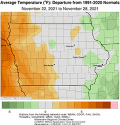
A rollercoaster of temperatures was reported across Iowa during the final reporting period with generally warmer temperatures west to near-normal conditions east; the statewide average temperature was 33.9 degrees, 2.0 degrees above normal. Though several weather systems passed through Iowa, unseasonably dry conditions persisted with most stations reporting no precipitation.
Clouds cleared in eastern Iowa on Sunday (21st) afternoon as blustery northwesterly winds held daytime highs in the low 30s north to mid 40s south. Scattered clouds pushed into southwestern Iowa as winds died down Monday (22nd) morning with temperatures dropping down to the middle teens over northern Iowa and mid 20s in southern Iowa. Winds gradually shifted to a southerly direction behind a dome of high pressure with afternoon temperatures hanging in the upper 30s and low 40s; conditions were slightly warmer in southwestern Iowa as a weak warm front lifted north into western Minnesota. Southerly return flow persisted overnight helping to cap temperatures in the upper 20s and low 30s prior to sunrise on Tuesday (23rd). Under sunny skies and with a secondary warm front propagating south to north through Iowa, afternoon highs rose into the mid to upper 60s in Iowa’s western third as upper 40s were recorded in eastern Iowa; the statewide average high was 56 degrees, 13 degrees above normal. Winds increased into the evening hours as a low pressure system over the Dakotas moved east with overnight lows remaining in the upper 30s and low 40s in eastern Iowa; colder temperatures were observed in the northwest as a cold front began moving across the state through Wednesday (24th). Winds shifted almost 180 degrees as the surface boundary swept over Iowa, ushering in a colder airmass. Highs ranged from the mid 30s northwest to upper 50s southeast as mostly cloudy skies developed.
Behind the front, morning temperatures on Thanksgiving (25th) plummeted into the low teens in northwestern Iowa with relatively warmer upper 20s and low 30s moving east. Pockets of snowflakes were also observed in central Iowa with Des Moines International Airport (Polk County) reporting a trace; light rain was also observed in extreme southeast Iowa. Skies cleared through the day with light northerly winds and cold highs in the 20s and low 30s; Algona (Kossuth County) observed a high temperature of 23 degrees, 16 degrees below average. Overnight temperatures remained frigid with many stations experiencing the coldest readings of the season; as of 7:00 am on Friday (26th) some northern stations reported single digits with a statewide average low of 14 degrees, nine degrees below normal. Partly cloudy skies remained as a disturbance approached Iowa with temperatures ranging from upper 40s and low 50s west to the 30s east. Light rain moved across sections of central and eastern Iowa with minor, but measurable totals ranging from 0.01 inch at ten stations to 0.03 inch in Cedar Rapids (Black Hawk County). More light rain fell as a low pressure center skirted northern Iowa through late Saturday (27th) morning. Several stations measured light totals with De Witt (Scott County) observing 0.04 inch. Gusty northwesterly winds built in behind the low as afternoon temperatures climbed into the 50s and low 60s in southern Iowa with mid to upper 40s northeast. Starry skies remained into Sunday (28th) morning with upper teens and low 30s reported northwest to southeast.
Weekly precipitation totals ranged from no accumulation at most of Iowa’s stations to 0.07 inch at Bellevue Lock and Dam (Jackson County). The statewide weekly average precipitation was 0.01 inch while the normal is 0.41 inch. Little Sioux (Harrison County) and Sioux City (Woodbury County) reported the week’s high temperature of 68 degrees on the 23rd, on average 25 degrees above normal. Several northern stations reported the week’s low temperature of eight degrees on the 26th, on average 12 degrees below normal. Four-inch soil temperatures ranged from the mid 30s north to low 40s south as of Sunday.

