Iowa Crop Progress and Condition Report
Nov. 8 – 14, 2021
DES MOINES, Iowa (Nov. 15, 2021) — Iowa Secretary of Agriculture Mike Naig commented today on the Iowa Crop Progress and Condition report released by the USDA National Agricultural Statistics Service. The report is released weekly from April through November.
“The first snowflakes of the season flew late last week, and soybean harvest is now 97 percent complete,” said Secretary Naig. “With less than 10 percent of corn left in the fields, the weather outlooks indicate cooler than average temperatures and below-normal precipitation chances.”
The weekly report is also available on the USDA’s website at nass.usda.gov.
Crop Report
Variable precipitation slowed harvest activities in parts of Iowa, allowing farmers 4.1 days suitable for fieldwork during the week ending November 14, 2021, according to the USDA, National Agricultural Statistics Service. Field activities included harvesting, baling corn stalks, applying fertilizer and anhydrous, and fall tillage.
Topsoil moisture levels rated 1 percent very short, 10 percent short, 81 percent adequate and 8 percent surplus. Subsoil moisture levels rated 6 percent very short, 25 percent short, 66 percent adequate and 3 percent surplus. Precipitation this week helped improve soil moisture levels slightly.
Ninety-one percent of Iowa’s corn for grain has been harvested, 4 days ahead of the five-year average. Moisture content of field corn being harvested for grain was 17 percent. Farmers in south central Iowa have over 20 percent of their corn for grain yet to harvest.
Iowa’s soybean crop harvest is virtually complete at 97 percent.
No issues with livestock were reported. Some cattle have been put out on corn stalks.
Weather Summary
Provided by Justin Glisan, Ph.D., State Climatologist, Iowa Department of Agriculture and Land Stewardship
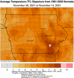
Multiple weather systems brought measurable rain along with the first snowfall of the season across portions of Iowa during the reporting period. Most of Iowa’s reporting stations observed above normal precipitation with northwest and southeast Iowa reporting near-normal conditions. Iowa also experienced warmer than average temperatures, even with a late week cold snap. The statewide average temperature was 42.7 degrees, 5.5 degrees above normal.
Warm southerly winds and sunshine helped boost daytime highs into the mid to upper 60s across Iowa on Sunday (7th) afternoon; a few stations reported low 70s with a statewide average high of 66 degrees, 16 degrees above normal. Winds began to shift to a northerly direction over the morning hours of Monday (8th) as a weak cold front pushed west to east through the state. Wind speeds gradually increased with highs ranging from the upper 50s behind the front in the northwest to mid 60s southeast. Clouds moved in over southern Iowa before midnight and remained into early Tuesday (9th). Morning lows stayed in the mid 40s to low 50s where clouds reduced surface heat loss while temperatures dipped into the upper 30s and low 40s where skies were clear. Daytime conditions were pleasant with a few scattered clouds passing through with highs in the mid to upper 50s north and some low 60s reported in southern Iowa. A few light showers moved across northwestern Iowa in the early afternoon, though totals were light. Westerly winds built in overnight into Wednesday (10th) as a strong low pressure system approached from the west. Winds shifted back to a southerly direction as showers and thunderstorms spun through southwestern Iowa after noon. The system produced a broad shield of moderate rainfall with a broad swath over the state’s middle third reporting heavy rainfall. Showers remained across northeastern Iowa as totals came in at 7:00 am on Thursday (11th); 70 stations measured an inch or more with most stations receiving at least 0.50 inch. A gauge near Chariton (Lucas County) observed 2.00 inches while Allerton (Wayne County) reported 2.98 inches with the statewide average at 0.86 inch.
Cold air and strong westerly winds filtered in behind the disturbance with sustained wind speeds in the 20 to 40 mph range. Light rain and some snow fell as the day wore on. Several stations reported a trace of snow with more than 25 stations observing at least 0.10 inch; Forest City (Winnebago County) measured 1.00 inch of snow as overall precipitation totals were under 0.10 inch with Rockwell City (Calhoun County) reporting 0.20 inch of rainfall. Strong winds persisted overnight into Friday (12th) with overcast skies and morning temperatures in the low 30s. Sustained westerly winds peaked in the 30 mph range with Sioux City Gateway Airport (Woodbury County) observing a 56 mph wind gust. Light rain and snow remained as several fast-moving upper-level disturbances propagated over Iowa. Temperatures hovered near freezing in northern Iowa while warming slightly farther south. Northwesterly winds died down overnight with cloud cover blanketing the state on Saturday (13th) morning. A complex of light rain moved into Iowa through the afternoon hours as a low pressure center pushed through Minnesota. Temperatures warmed into the late night hours with upper 30s to mid 40s reported at a majority of Iowa’s stations. A second wave of light rain with some snowflakes crossed Iowa overnight into Sunday (14th) morning with minor totals reported across the state.
Weekly precipitation totals ranged from 0.10 inch at Rock Valley (Sioux County) to 2.98 inches in Allerton. The statewide weekly average precipitation was 0.93 inch while the normal is 0.46 inch. Shenandoah (Page County) reported the week’s high temperature of 72 degrees on the 7th, 18 degrees above normal. Forest City reported the week’s low temperature of 20 degrees on the 13th, five degrees below normal.

