Iowa Crop Progress and Condition Report
April 15-21, 2024
DES MOINES, Iowa (April 22, 2024) – Iowa Secretary of Agriculture Mike Naig commented on the Iowa Crop Progress and Condition Report released by the USDA National Agricultural Statistics Service. The report is released weekly April through November. Additionally, the Iowa Department of Agriculture and Land Stewardship provides a weather summary each week during this time.
“Planters temporarily stopped rolling last week as thunderstorms produced severe weather across portions of Iowa along with above-average rainfall,” Secretary Naig. “Warmer temperatures are forecasted this week with a more active weather pattern persisting as farmers look for windows of opportunity to get back into the field.”
The weekly report is also available on the USDA’s website at nass.usda.gov.
Crop Report
Although the week began with above normal temperatures, multiple storm systems brought cooler temperatures and much-needed rain, which only allowed Iowa farmers 3.0 days suitable for fieldwork during the week ending April 21, 2024, according to the USDA, National Agricultural Statistics Service.
Corn, soybean and oat planting continued this week when field conditions allowed. Topsoil moisture condition rated 10 percent very short, 27 percent short, 60 percent adequate and 3 percent surplus. Subsoil moisture condition rated 19 percent very short, 36 percent short, 43 percent adequate and 2 percent surplus.
Corn planted reached 13 percent complete, 3 days ahead of last year and the 5-year average. Eight percent of the expected soybean crop has been planted, 4 days ahead of last year and 6 days ahead of the average. Seventy-eight percent of the expected oat crop has been planted, 1 week ahead of last year and 8 days ahead of the 5-year average. Thirty-four percent of the oat crop has emerged, 10 days ahead of last year.
Pastures and hay ground continue to green up due to much-needed rain. No reports of cattle turned out onto pasture yet.
Weather Summary
Provided by Justin Glisan, Ph.D., State Climatologist, Iowa Department of Agriculture and Land Stewardship
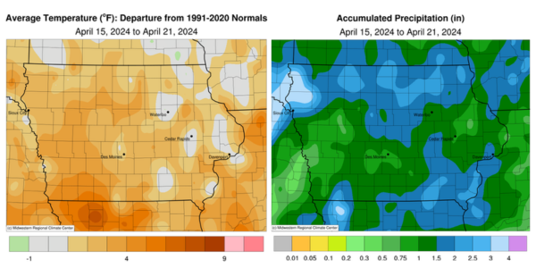
The first widespread severe weather event occurred early in the reporting period with all modes of hazards occurring through multiple waves of thunderstorms. At least 15 tornadoes were observed across Iowa along with large hail and straight-line winds. These thunderstorms brought widespread, above-average rainfall as well. Conditions were slightly warmer than average, especially over southern Iowa; the statewide average temperature was 51.6 degrees, 2.2 degrees above normal.
Sunday (14th) afternoon was sunny and unseasonably warm as daytime temperatures rose into the mid to upper 80s across southern Iowa; stations farther north reported upper 70s and low 80s while the statewide average high was 82 degrees, 22 degrees above normal. Monday (15th) morning started with lows ranging from the mid 40s northeast to mid 50s southeast under clear skies and winds in a generally easterly direction. Afternoon highs returned to the upper 70s and low 80s with wind speeds rising as a strong low-pressure center approached Iowa. Thundershowers pushed into southwestern Iowa towards midnight, expanding into northern Iowa before daybreak on Tuesday (16th). A second, stronger line formed during the later morning hours with embedded strong to severe thunderstorms. The first tornado of the day formed near Minburn (Dallas County) and traveled nearly seven miles, producing some structural damage. As the initial line strengthened and moved northeast, a more narrow but equally strong line formed behind, producing several severe and tornado-warned storms in eastern Iowa. Enough wind shear and instability over northwestern Iowa fired off shallow-topped supercells that spun up a few weak tornadoes; Rockwell City (Calhoun County) experienced an EF-1-rated tornado with wind speeds estimated at 100 mph. A longer track EF-2 was observed near Salem (Henry County), producing winds near 130 mph and lasting for 42 miles; there were numerous hail and high wind events across the state as well. Beneficial rain totals were observed across broad south-to-north swaths, particularly in northern and southeastern Iowa, with more than 110 stations collecting at least an inch; a station in Burlington (Des Moines County) reported 1.92 inches while Postville (Allamakee County) observed 2.62 inches with a statewide average of 0.74 inch.
Blustery, westerly winds built in as the system exited with overcast skies lingering into Wednesday (17th). Daytime temperatures rose into the upper 60s over southwest Iowa where skies were clearing. Another weather disturbance brought additional rainfall to Iowa just before midnight and through much of Thursday (18th) with most stations observing at least 0.30 inch. The wettest conditions were found in the northwest and along the Iowa-Missouri border with numerous one-inch or greater totals; Le Mars (Plymouth County) measured an inch on the dot while two stations in Bloomfield (Davis County) recorded 1.93 to 1.97 inches. Skies began to clear late in the evening as morning lows on Friday (19th) dropped below freezing in northwest Iowa. Westerly winds increased through the day as spotty clouds drifted across the state with upper 40s north to upper 50s south. Starry skies into Saturday (20th) allowed temperatures to settle in the low 30s statewide with persisting westerly winds. Overcast conditions developed through the day with chilly temperatures in the mid 40s to low 50s; the statewide average high was 48 degrees, 15 degrees below normal. Skies cleared overnight with low to mid 20s registering in eastern Iowa on Sunday (21st) morning.
Weekly precipitation totals ranged from 0.51 inch in Sac City (Sac County) to 4.00 inches in Remsen (Plymouth County). The statewide weekly average precipitation was 1.58 inches, while the normal is 0.91 inch. Winterset (Madison County) reported the week’s high temperature of 89 degrees on the 14th, 29 degrees above average. Elkader (Clayton County) reported the week’s low temperature of 23 degrees on the 21st, 13 degrees below normal. Four-inch soil temperatures were in the mid to upper 40s statewide with low 50s reported in far western Iowa as of Sunday.
