Iowa Crop Progress and Condition Report
Oct. 9-15, 2023
DES MOINES, Iowa (Oct. 16, 2023) — Iowa Secretary of Agriculture Mike Naig commented on the Iowa Crop Progress and Condition Report released by the USDA National Agricultural Statistics Service. The report is released weekly April through November. Additionally, the Iowa Department of Agriculture and Land Stewardship provides a weather summary each week during this time.
“The widespread rain is definitely ill-timed yet still badly needed,” said Sec. Naig. “Though combines are sidelined, and harvest progress is slowed, the rain will have a positive impact on re-charging soil moisture, establishing cover crops and replenishing pastures.”
The weekly report is also available on the USDA’s website at nass.usda.gov.
Crop Report
Iowa was cold and damp this week with the northern two-thirds of State receiving above average precipitation, limiting days suitable for fieldwork to 4.2 during the week ending October 15, 2023, according to the USDA, National Agricultural Statistics Service. Corn and soybean harvest continued to be the main field activities for the week, although there were some reports of fall tillage and dry fertilizer being applied.
Topsoil moisture condition rated 19 percent very short, 38 percent short, 40 percent adequate and 3 percent surplus. Subsoil moisture condition rated 31 percent very short, 43 percent short, 24 percent adequate and 2 percent surplus.
Virtually all the State’s corn crop has reached maturity. Corn harvested for grain reached 42 percent statewide, 3 days ahead of last year and 5 days ahead of the average. Moisture content of field corn being harvested for grain was at 17 percent. Corn condition rated 51 percent good to excellent. Soybeans dropping leaves was 98 percent this week. Soybeans harvested reached 74 percent, 1 day ahead of last year and 9 days ahead of the average.
Pasture condition rated 17 percent good to excellent. Livestock conditions were generally good. Some producers continue to haul hay and purchase hay in preparation for winter, while others have turned cattle out to feed on fields of corn stalks.
Weather Summary
Provided by Justin Glisan, Ph.D., State Climatologist, Iowa Department of Agriculture and Land Stewardship
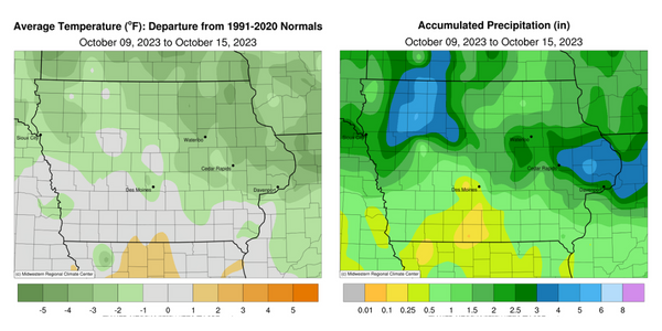
A large and slow-moving low-pressure system spun several waves of showers and thunderstorms across Iowa during the reporting period. Stations across Iowa’s northern half received more than a month’s worth of rainfall. Temperatures were also cooler than average where cloud cover and rain were present; the statewide average temperature was 50.2 degrees, 2.7 degrees below normal.
Daytime highs on Sunday (8th) rose into the upper 60s and low 70s as spotty clouds dotted the sky under light northerly winds. Mostly clear skies into Monday (9th) morning allowed temperatures to fall below freezing at many Iowa stations while upper 30s and low 40s were observed in eastern Iowa. Afternoon conditions were partly sunny with highs in the upper 50s and low 60s as northerly winds increased. Starry skies persisted through Tuesday (10th) morning with an easterly shifting wind and temperatures in the upper 20s northwest to upper 30s southeast. Several southwestern stations registered highs in the lower 70s with temperatures 10-15 degrees cooler in northern Iowa. Clouds increased over southern Iowa into early Wednesday (11th) as showers and a few thunderstorms moved through the area. General totals were under 0.20 inch, though Truro (Madison County) measured 0.26 inch and College Springs (Page County) received 0.36 inch. Additional showers and a few severe thunderstorms fired across eastern Iowa, later expanding farther north and west, ahead of a large low-pressure system that was approaching Iowa. A second wave of showers pushed into western Iowa just before daybreak on Thursday (12th) with a broad shield of rain persisting over northern Iowa through the afternoon hours. Initial rainfall totals exceeded 1.00 inch at 60 stations with the highest totals in eastern Iowa and a statewide average of 0.47 inch; a station in Davenport (Scott County) observed 2.02 inches while Camanche (Clinton County) reported 3.05 inches. Easterly wind continued through the day with upper 40s northeast to mid-60s southwest.
The low-pressure center finally moved into western Iowa after midnight on Friday (13th) with moderate to heavy rain falling from several waves of showers and thunderstorms. Nearly 30 northwest stations observed at least 2.00 inches with 10 stations registering more than 3.00 inches; Milford (Dickinson County) reported 3.09 inches with 3.75 inches in Storm Lake (Buena Vista County). Totals tapered off farther southeast though most stations across Iowa’s northwestern two-thirds observed at least 0.50 inch; the statewide average total was 0.76 inch. Overcast skies persisted through the day with highs in the upper 50s and low 60s as stronger storms formed across central Iowa during the late afternoon. Ample instability and atmospheric spin associated with the low-pressure center forced a few tornado-warned thunderstorms, though no rotation was spotted. The system finally exited eastern Iowa early on Saturday (14th) with 24-hour totals reported at 7:00 a.m. highest from central to eastern Iowa. More than 30 additional stations hit an inch or more with 2.68 inches in Lowden (Cedar County); general totals at most stations were in the 0.25- to 0.75-inch range with a statewide average of 0.52 inch. Overcast skies hid the annular solar eclipse as spotty showers spun in on the backside of the low. Daytime temperatures were in the 50s as gusty northerly winds built in. Overnight lows did not drop significantly as thick stratus cloud remained; temperatures remained in the mid to upper 40s on Sunday (15th) morning.
Weekly precipitation totals ranged from 0.07 inch in Davis City (Decatur County) to 5.29 inches in Sioux Rapids (Buena Vista County). The statewide weekly average precipitation was 1.85 inches, almost three times the normal of 0.64 inch. Lamoni (Decatur County) reported the week’s high temperature of 81 degrees on the 12th, 14 degrees above normal. Elkader (Clayton County) reported the week’s low temperature of 23 degrees on the 11th, 16 degrees below normal.
