Iowa Crop Progress and Condition Report
Week of April 1-7, 2019
DES MOINES, Iowa (April 8, 2019) – Iowa Secretary of Agriculture Mike Naig today commented on the Iowa Crop Progress and Condition report released by the USDA National Agricultural Statistics Service. The report is released weekly from April through November.
"The recent warming trend has helped green up cover crops in some parts of the state, which is a sure sign of spring," said Iowa Secretary of Agriculture Mike Naig. "The forecast shows a chance of mixed precipitation over the next few days so widespread field work is still likely a few weeks out."
The weekly report is also available on the USDA’s site at nass.usda.gov/ia.
CROP REPORT
Cool temperatures and rain throughout Iowa kept fields from drying out enough for fieldwork during the week ending April 7, 2019, according to USDA’s National Agricultural Statistics Service.
Statewide there was just 0.8 day suitable for fieldwork. Fieldwork activities were limited with some farmers spreading manure and applying dry fertilizer on fields able to support the equipment. Topsoil moisture levels rated 0 percent very short, 0 percent short, 44 percent adequate and 56 percent surplus. Subsoil moisture levels rated 0 percent very short, 0 percent short, 46 percent adequate and 54 percent surplus.
Two percent of oats have been planted statewide, nine days behind the 5-year average and nearly a week behind last year. This is the smallest percent planted by this time since 2008.
Cover crops and hay continue to green as warmer temperatures induced growth. Livestock and feedlot conditions have improved, but feedlots remain muddy.
IOWA PRELIMINARY WEATHER SUMMARY
Provided by Justin Glisan, Ph.D., State Climatologist Iowa Department of Agriculture and Land Stewardship
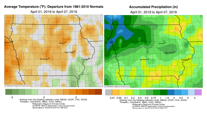
April’s first week was wetter than normal across Iowa’s northwest quadrant with the rest of state experiencing unseasonably dry conditions; measurable rain was reported every day.
Temperatures were generally above average by two to three degrees, though cooler in the southeast corner. A series of weak cold fronts moved through Iowa at the beginning of the week, the first of which occurred late Monday (1st) into Tuesday (2nd) morning. Much of Iowa saw measurable rainfall from another frontal passage on Wednesday (3rd). Rainfall totals through 7:00 am on Thursday (4th) were above one inch at eight stations in northwest Iowa; Storm Lake (Buena Vista County) reported 1.73 inches.
Daytime temperatures cooled into the mid-40s across northern Iowa. Friday (5th) was warm with highs in the upper 50s and lower 60s. Rain fell across northern Iowa overnight into Saturday (6th), which was the week’s warmest day. Highs were 15 to 20 degrees warmer than average, reaching into the upper 70s in southern Iowa.
A low pressure system moved through Iowa Saturday night into Sunday (7th). Dubuque (Dubuque County) reported 0.75 inches of rain. Thundershowers reformed in eastern Iowa on Sunday evening. Preliminary rainfall totals for the week averaged 0.54 inches, while the normal is 0.65 inches. Atlantic (Cass County) and Sac City (Sac County) observed the week’s high of 78 degrees on the 6th, on average 20 degrees above normal. Denison (Crawford County) and Little Sioux (Harrison County) reported a low of 16 degrees on the 1st, 15 degrees below average. Orange City (Sioux County) reported the highest rainfall total of the week at 2.35 inches.
Four-inch soil temperatures have warmed into the mid to upper 50s across the southern two-thirds of Iowa; soil temperatures in northern Iowa are in the upper 40s and lower 50s.
