Iowa Crop Progress and Condition Report
Aug. 26–Sept. 1, 2024
DES MOINES, Iowa (Sept. 3, 2024) — Iowa Secretary of Agriculture Mike Naig commented on the Iowa Crop Progress and Condition Report released by the USDA National Agricultural Statistics Service. The report is released weekly April through November. Additionally, the Iowa Department of Agriculture and Land Stewardship provides a weather summary each week during this time.
“September is always a busy month as farmers are beginning to make harvest preparations while also seeding cover crops and chopping silage,” said Secretary Naig. “As this year’s crop heads toward maturity, the outlook for the first half of September indicates the continuation of warm and dry conditions.”
The weekly report is also available on the USDA’s website at nass.usda.gov.
Crop Report
The State experienced hot conditions and scattered rain this past week. Iowa farmers averaged 5.3 days suitable for fieldwork during the week ending September 1, 2024, according to the USDA, National Agricultural Statistics Service. Activities included preparing for the fall harvest and hay cutting.
Topsoil moisture condition rated 2 percent very short, 20 percent short, 76 percent adequate and 2 percent surplus. Subsoil moisture condition rated 3 percent very short, 19 percent short, 75 percent adequate and 3 percent surplus.
Corn in the dough stage or beyond reached 94 percent this week. Sixty-one percent of the corn crop reached the dent stage, 5 days behind last year and 1 day behind the five-year average. Corn mature reached 10 percent, 2 days behind last year but 1 day ahead of the five-year average. Corn condition rated 77 percent good to excellent. Soybeans setting pods reached 95 percent. Soybeans coloring reached 18 percent, 4 days behind last year and 2 days behind the five-year average. Soybean dropping leaves began at 2 percent. Soybean condition was 77 percent good to excellent.
The State’s third cutting of alfalfa hay reached 88 percent, 1 week behind last year but 1 week ahead of the five-year average. Pasture condition rated 64 percent good to excellent.
Weather Summary
Provided by Justin Glisan, Ph.D., State Climatologist, Iowa Department of Agriculture and Land Stewardship
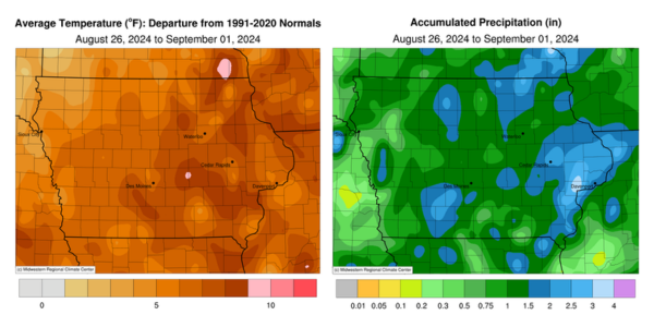
The last reporting period of August was unseasonably warm across Iowa with pockets of positive departures approaching nine degrees; the statewide average temperature was 75.7 degrees, 6.7 degrees above normal. Much of the state also experienced wetter than normal conditions with many stations collecting surplus rainfall in the 0.50- to 1.00-inch range.
Southerly winds boosted Sunday (25th) afternoon temperatures into the low to mid 90s over southern Iowa as clouds increased over northern Iowa. Overnight temperatures through Monday (26th) morning were well above normal for late August, holding in the low to mid 70s at most stations. Daytime temperatures quickly rose into the mid to upper 90s with dewpoint temperatures in the upper 70s and low 80s; the statewide average high was 95 degrees, 14 degrees above normal along with triple digit heat index values. A weak cold front dropped southeast through the state on Tuesday (27th), producing showers over northern Iowa while stronger thunderstorms fired along an outflow boundary in southeastern Iowa through the evening hours. Daytime temperatures varied from the upper 70s in northwest Iowa behind the front to the mid 90s southeast. Rainfall totals were highest over southern Iowa with nearly 30 stations collecting at least an inch of rain. Three stations in Burlington (Des Moines County) registered from 2.13 to 2.53 inches. Totals farther north and west were generally under a few tenths of an inch.
Morning lows on Wednesday (28th) varied from the upper 50s north to upper 60s south as fog and partly cloudy skies were also reported. Cloudy skies remained through the day with temperatures in the low to mid 80s under southerly winds. A small complex of thundershowers formed after midnight in northeast Iowa, leaving behind 1.55 inches at Lime Springs (Howard County) with lesser totals at a handful of stations. A strong cold front propagated across Iowa on Thursday (29th) leaving widespread totals of over one inch at more than 230 stations National Weather Service (NWS) and Community Collaborative Rain, Hail and Snow (CoCoRaHS) gauges. Eastern Iowa received the highest totals as the front slowly moved out of the state Friday (30th) morning; Marion (Linn County) registered 2.85 inches with a statewide average rainfall of 1.06 inches. Winds shifted to the northwest as cloud cover cleared southeastern Iowa by the early afternoon with daytime highs holding in the 70s. Light and variable winds developed through Saturday (31st) with morning temperatures in the 50s under clear skies. Afternoon conditions were pleasant with low 80s and southwesterly winds. Overnight lows into Sunday (1st) ranged from the mid 50s north to low 60s south.
Weekly rain totals ranged from 0.19 inch at Cherokee (Cherokee County) to 4.05 inches in Muscatine (Muscatine County). The statewide weekly average rainfall was 1.30 inches; the normal is 0.88 inch. Osceola (Clarke County) and Shenandoah (Page County) reported the week’s high temperature of 100 degrees on the 26th, on average 17 degrees above normal. Mason City Municipal Airport (Cerro Gordo County) reported the week’s low temperature of 47 degrees on the 1st, seven degrees below normal.
