Iowa Crop Progress and Condition Report
Oct. 21–27, 2024
DES MOINES, Iowa (Oct. 28, 2024) – Iowa Secretary of Agriculture Mike Naig commented on the Iowa Crop Progress and Condition Report released by the USDA National Agricultural Statistics Service. The report is released weekly April through November. Additionally, the Iowa Department of Agriculture and Land Stewardship provides a weather summary each week during this time.
“Continued warm temperatures and dry conditions last week allowed for harvest to push forward at a brisk pace. While corn harvest is likely to continue well into November, soybean harvest across Iowa is nearing completion,” said Secretary Naig. “The extended lack of rainfall has resulted in drought conditions spreading across many areas, but a mid-week system has the potential to bring widespread moisture to much of Iowa. Following what is likely to be one of the driest Octobers on record, weather outlooks for early November are indicating more chances for rainfall.”
The weekly report is also available on the USDA’s website at nass.usda.gov.
Crop Report
Row crop harvest was ahead of normal as Iowa’s farmers had 6.7 days suitable for fieldwork during the week ending October 27, 2024, according to the USDA’s National Agricultural Statistics Service. Field activities included harvesting corn and soybeans, completing fall tillage, and applying fall fertilizer.
Topsoil moisture condition rated 43 percent very short, 42 percent short, 15 percent adequate and 0 percent surplus. Topsoil moisture condition rated at least 75 percent short to very short across the State. Subsoil moisture condition rated 34 percent very short, 46 percent short, 20 percent adequate and 0 percent surplus.
Corn harvest for grain reached 84 percent statewide, almost a week ahead of last year and 12 days ahead of the five-year average. South central Iowa farmers still have 34 percent of their corn for grain remaining to harvest, while farmers have already harvested 91 percent in north central Iowa. Moisture content of field corn being harvested was 14 percent. Iowa’s soybean harvest was nearly complete at 96 percent.
Pasture condition continued to fall and rated 19 percent good to excellent this week. Pastures have largely gone dormant due to shorter daylight hours, cooler temperatures, and dry conditions.
Weather Summary
Provided by Justin Glisan, Ph.D., State Climatologist, Iowa Department of Agriculture and Land Stewardship
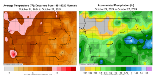
Widespread rainfall returned to Iowa over the reporting period with the highest totals found in east-central Iowa; the weekly statewide total was more than the previous four weeks combined, though still below the 30-year climatological average. Temperatures remained unseasonably warm with a statewide average of 53.6 degrees, 4.2 degrees above normal.
Strong southwesterly winds helped boost Sunday (20th) afternoon temperatures into the low 80s across most of Iowa. Clear conditions continued into Monday (21st) with morning temperatures ranging from the mid 40s southeast to upper 50s northwest. Afternoon temperatures returned to the low 80s statewide with sunny skies and southerly winds persisting. Clouds increased over western Iowa prior to sunset as a band of showers, with locally heavier rain, pushed into Iowa ahead of a low pressure system. Showers and a few thunderstorms increased in coverage as the system moved through central and eastern Iowa into late Tuesday (22nd) morning. Moderate rain was reported along a narrow line in eastern Iowa before the system cleared the state. Most stations reporting rain had totals under 0.15 inch with higher amounts ranging from 0.21 inch in Washington (Washington County) to 0.41 inch near Council Bluffs (Pottawattamie County). Westerly winds built in behind the system with clearing skies in eastern Iowa and highs in the 70s west to upper 60s east. Winds shifted northwesterly overnight as patchy cloud cover and light rain moved over southern Iowa.
Conditions cleared out through Wednesday (23rd) with afternoon conditions in the upper 50s to mid 60s, near seasonal for late October. Overnight lows into Thursday (24th) were below freezing in eastern Iowa, where patchy frozen fog was observed; upper 40s and low 50s were reported farther west. A shift back to gusty southerly winds ahead of another low pressure center helped fire thunderstorms across southern Iowa into the afternoon hours. A more concentrated line of showers and thunderstorms formed along the low’s attendant cold front as it sped through central Iowa; several storms became severe-warned with pea to penny-sized hail along with heavier rainfall rates. Thirty stations in eastern Iowa reported at least an inch of rain with the highest totals in Johnson County, where 1.93 inches was registered in North Liberty. Many stations observed rainfall in the 0.30 to 0.70-inch range. The system cleared eastern Iowa by sunrise on Friday (25th) with morning lows in the mid 30s northwest to low 50s southeast under clear skies. Sunshine and northerly winds prevailed with highs holding in the upper 50s and low 60s. Saturday (26th) dawned chilly with temperatures in the 20s across western Iowa while conditions were up to 10 degrees warmer in eastern Iowa. Daytime temperatures rose back into the upper 50s and low 60s as blustery southerly winds returned. Starry skies were visible into Sunday (27th) with morning lows in the upper 30s and low 40s.
Weekly precipitation totals ranged from no accumulation in northwest Iowa to 2.18 inches in Solon (Johnson County). The weekly statewide average precipitation was 0.24 inch while the normal is 0.53 inch. Spencer Municipal Airport (Clay County) reported the week’s high temperature of 85 degrees on the 21st, 27 degrees above normal. Mapleton (Monona County) and Mason City (Cerro Gordo County) reported the week’s low temperature of 20 degrees on the 27th, on average 13 degrees below normal.
